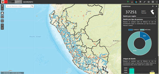
Skills

Some general skills

Python

95%

JavaScript

75%

.Net

60%

GIS

100%

Databases

70%

NodeJS

30%

Git + GitHUB

80%

Data Science

50%

WebScraping

80%

Experience


GIS Developer

Ministry of housing, construction and sanitation

Mar 2020 – Present Av. República de Panamá 3650, San Ididro Lima-Perú

Responsibilities include:

  • GIS Analysis: ArcGIS Pro, Desktop and Portal for ArcGIS, Operational Dashboard, survey123
  • Developing: Python, JavaScript, PostgreSQL
  • Systems: Cloration Strategy


Geographic Information Systems Analyst

San Isidro Local Government

Jul 2019 – Dec 2019 Av. Augusto Tamayo 180, San Ididro Lima-Perú

Responsibilities include:

  • GIS Analysis: ArcGIS Pro, Desktop and Online, QGIS, TransCAD, Tableau
  • Developing: Python, JavaScript, PostgreSQL, PostGIS, WebScraping
  • Systems: Urban Observatory, SIC


Geographic Information Systems Analyst

Mining and Metallurgical Geological Institute - Ingemmet

Apr 2017 – Jun 2019 Av. Canadá 1470, San Borja Lima-Perú

Responsibilities include:

  • Analysis: ArcGIS Pro, Desktop, Server and Online
  • Developing: Python, JavaScript, vb.net, C#, Oracle PLSQL, DojoJS, WebAppBuilder for ArcGIS
  • Assistance: Citrix
  • Systems: Geocatmin, Sigcatmin, Online UEAs Request Module, Online Accumulation Request Module


Programmer Analyst

National Institute of Statistics and Informatics - INEI

Dec 2015 – Jun 2017 Av. Gral. Garzón 654 - 658, Jesús María Lima-Perú
  • Analysis: ArcGIS Desktop, QGIS
  • Developing: Python, SQLServer, Plugins para QGIS
  • Systems: SIGIT, Automated Rural Segementation Algorithm
  • Territorial instructor


Subdivision of Geodesy and Topography - Practitioner

Organization of Formalization for Informal Property – COFOPRI

Jun 2014 – Dec 2014 v. Paseo de la República 3135 - 3137, San Isidro Lima-Perú
Perform geodetic surveys (georeferencing) with Trimble R7 GNSS Receiver equipment and LEICA 1200ATX, topographic survey with Total Stations TOPCOM ES-105, use of brand levels LEICA DNA03, GPS navigator GARMIN, elaboration of monographic sheets associated with the points of geodetic control of order C, software management AutoCAD for the edition of topographic plans and management of Geographic Information Systems with ArcGIS for the thematic representation and database.

Projects

Personal initiatives and published professional experiences

*

Real-time monitoring of field surveys for the National Rural Sanitation Program of the Ministry of Housing (Danfo.js, Api ArGIS for Javascrip 4.0, Chart.js, Bulma.css)

Map viewer for miners in the process of formalization (Grunt.js, Yeoman.js, WebAppBuilder Developer Edition, Api Javascript ArcGIS 3.4, Bulma.css, Chart.js)

Download WebMapServices easily; developed in Python, Briefcase

Download WebMapServices easily; developed in javascript

Project to send information to Google Drive with Django

Display space of Urban Indicators of the Municipality of San Isidro for decision making

Representation of my daily activity in front of a computer by counting keys pressed per hour

Contact